2022. 1. 29. 20:46ㆍ천문, 천체/오늘의 천문학 사진

서쪽 달, 동쪽 바다(Western Moon, Eastern Sea)
(2022. 1. 28)
이미지 제공 및 저작권: 톰 글렌
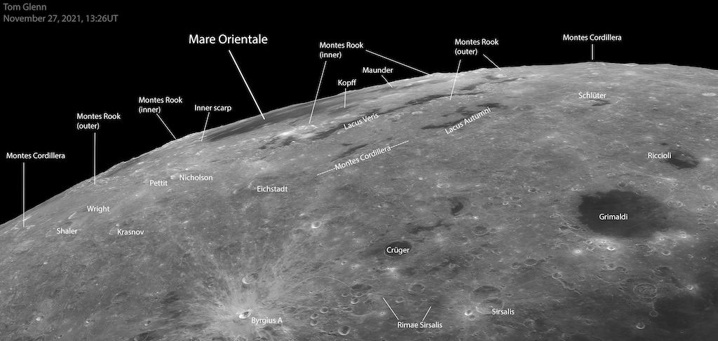
라틴어로 동쪽 바다를 뜻하는 마레 오리엔탈레(Mare Orientale)는 가장 큰 규모의 달 지형 중 하나이다. 달 표면 대형 충돌 분지 중 가장 어린 것은 지구의 각도에서는 보기가 매우 어렵다. 그럼에도 불구하고, 달 앞면이 적절히 기울어지거나 칭동하는 시기에 촬영된, 동쪽 바다가 달의 서쪽 가장자리를 따라 극도로 짧아진, 이 선명한 망원경 사진 상단 중앙 부근에서 발견된다. 약 30억 년 전 소행성의 충돌로 형성되었으며, 거의 1000km에 달하는 충돌 분지의 동심원은 달 지각에 잔물결을 이루고 있다. 하지만 그것들은 달 궤도 우주선에서 촬영된 지역의 직접적인 사진에서 더 쉽게 발견할 수 있다. 그렇다면 왜 동쪽 바다는 달의 서쪽 끝에 있나요? 동쪽 바다의 달의 지형은 1961년 이전에 이름이 붙여졌다. 그 때는 달 지도에 동쪽과 서쪽을 표기하는 방법이 반대였다.
원문 :
Astronomy Picture of the Day
2022 January 28
Western Moon, Eastern Sea
Image Credit & Copyright: Tom Glenn
Explanation: The Mare Orientale, Latin for Eastern Sea, is one of the most striking large scale lunar features. The youngest of the large lunar impact basins it's very difficult to see from an earthbound perspective. Still, taken during a period of favorable tilt, or libration of the lunar nearside, the Eastern Sea can be found near top center in this sharp telescopic view, extremely foreshortened along the Moon's western edge. Formed by the impact of an asteroid over 3 billion years ago and nearly 1000 kilometers across, the impact basin's concentric circular features are ripples in the lunar crust. But they are a little easier to spot in more direct images of the region taken from lunar orbit. So why is the Eastern Sea at the Moon's western edge? The Mare Orientale lunar feature was named before 1961. That's when the convention labeling east and west on lunar maps was reversed.
'천문, 천체 > 오늘의 천문학 사진' 카테고리의 다른 글
| SOHO 위성이 찰영한 태양 홍염(A Solar Prominence from SOHO) (0) | 2022.01.31 |
|---|---|
| 화로자리 은하단(The Fornax Cluster of Galaxies) (0) | 2022.01.30 |
| 오리온 성운 남쪽(South of Orion) (0) | 2022.01.28 |
| 어느 날 새벽 안개 속의 일출 (0) | 2022.01.27 |
| 안타레스 근처의 별, 먼지, 가스(Stars, Dust, and Gas Near Antares) (0) | 2022.01.27 |